Indonesia tsunami: an underwater landslide likely caused the widespread destruction in Sulawesi
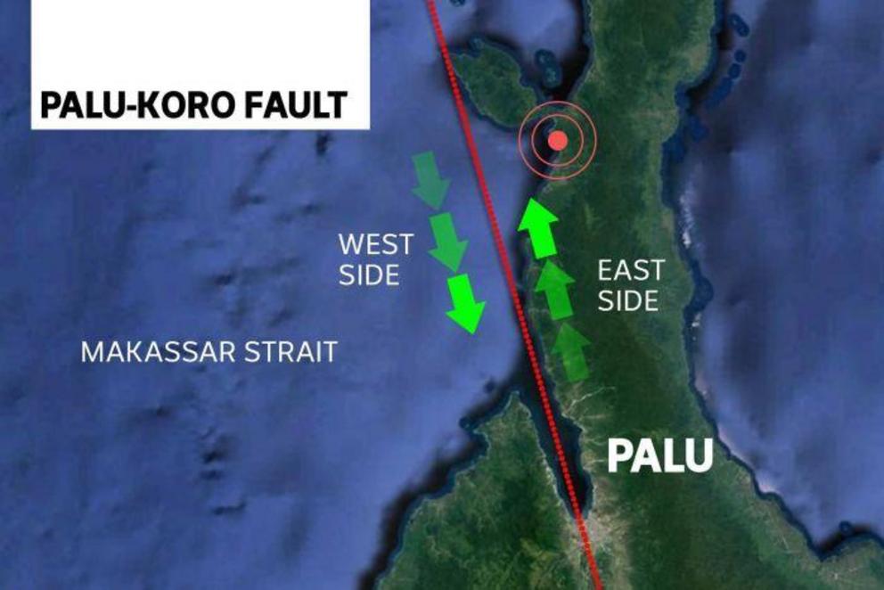
Experts agree the quake was caused by the Palu-Koro faultline, running through Sulawesi.
The town of Palu stretches out across a flat plain made fertile with river sediments. It's at the head of a narrow bay sheltered by high mountains that drop steeply into the sea.
But experts say everything that made the area around the now-ruined town perfect for a thriving settlement may also have made it vulnerable to disaster.
As relief workers move in to help survivors left destitute by the earthquake and tsunami that struck Indonesia's Sulawesi island, geological experts are beginning to form a picture of how the disaster caused such devastation.
They say a chain of geological events set off by the violent quake liquefied the loose soil and possibly caused an underwater landslide, triggering a tsunami wave that may have been intensified by the shape of the bay.
How did the quake cause a tsunami?
 The large displacement of land beneath the sea created the tsunami.
Data is still being collected on the magnitude-7.5 quake, as well as the before and after shocks.
But experts agreed it was likely caused by movement of the Palu-Koro fault which runs almost north to south down Sulawesi on a line through Palu's narrow bay.
"It's one of the world's most active faults," said Dr Jane Cunneen from Curtain University's School of Earth and Planetary Sciences.
The Palu-Koro is a strike-slip fault, where the two sides slide past each other horizontally, unlike a thrust fault which pushes one side over the other.
The fault usually shifts by 30 to 40 millimetres a year, with the western side heading south while the eastern edge moves north.
Adam Switzer, associate professor at the Asian School of the Environment, said quakes on this type of fault cause tremendous shaking and can end up with the two sides moving significantly.
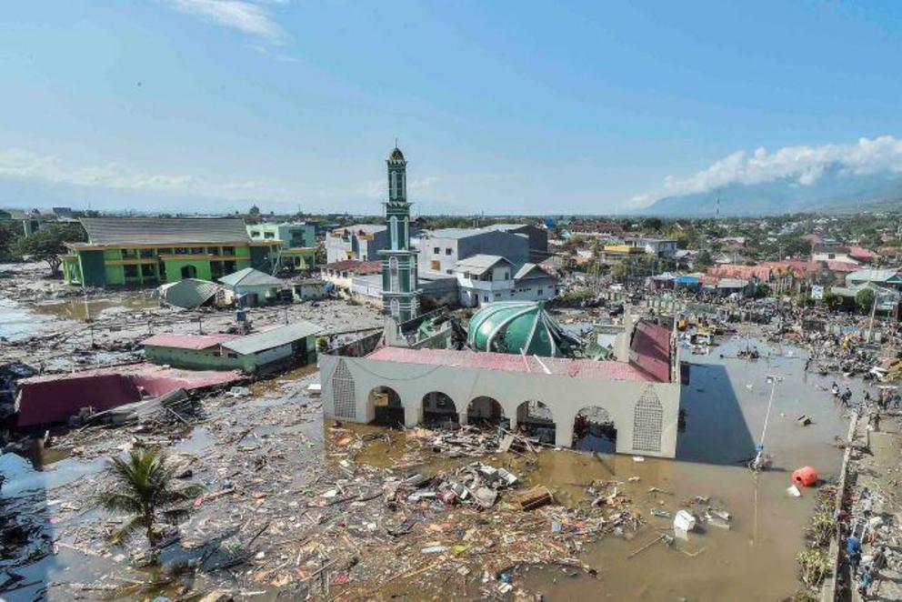 Many buildings, including this mosque in Palu, were destroyed by the tsunami.
"Early indications are that there were several metres of displacement," he said.
The epicentre of the quake does not necessarily lie on the main line of the fault and in the case of the Sulawesi quake it is already clear it was located north of the main fault.
According to Phil Cummins from the ANU's School of Earth Sciences, it remains something of a mystery how a strike-slip fault triggered a tsunami.
A thrust quake is more likely to trigger a tsunami, he said, because its vertical motion pushes a column of seawater upwards, setting a wave in motion.
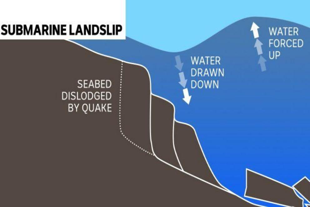
What all the experts the ABC talked to agree is that the earthquake likely caused an underwater landslide.
Palu's steep mountains continue underwater to great depths, so one or more of their slopes could have been damaged by the quake, displacing so much water it caused the tsunami.
What happens when this occurs is a section of the seabed is dislodged and slips downwards, drawing water down where it originated, and forcing it up where it lands.
"Either of those result in wave motion," Professor Cummins said.
Did the bay's shape make it worse?
 The shape of Palu's bay likely intensified the effect of the wave.
Experts told the ABC it is likely the bay's narrow shape intensified the effect of the wave as it funnelled through the narrow opening.
But scientists will need to collect more information about where the tsunami originated, and what set it off before they can work out how much of a role it played.
What researchers will be looking to resolve is whether the wave was generated inside or outside the bay, and whether there were possibly multiple sources.
Professor Cummins says their efforts will be complicated by having to rely on eyewitnesses because there were no working tide gauges in the bay when the tsunami struck.
Teams of researchers will soon begin to comb the disaster site for evidence of where the waves ended up, and how high they reached, so they can better understand what happened.
If the wave originated outside the bay, or near the mouth of the bay, the shape of the feature could have intensified its power.
Another possibility, according to Professor Cummins, is that one of the edges of the bay could have been displaced, setting a wave in motion and creating the same sloshing effect you would see in a bath.
Why did so much liquefaction occur?
Several accounts have emerged from the disaster area of buildings slipping and sliding across the landscape as if they were moving on water.
The local disaster agency says mud and sludge rose up out of the ground, toppling houses and trees.
The phenomenon, called liquefaction, is a result of the city being built on a flat plain formed from loose sediment, or sandy soil.
A high water table also contributes to causing the ground to become fluid and unstable, with water pushing up between cracks in the soil as the ground shakes.
The shaky nature of this particular quake would have exacerbated the liquefaction, by agitating the water to such an extent that mud bubbled up from underground, weakening foundations, and uprooting trees.