Hunga Tonga-Hunga Ha'apai eruption released the highest volcanic plume ever recorded
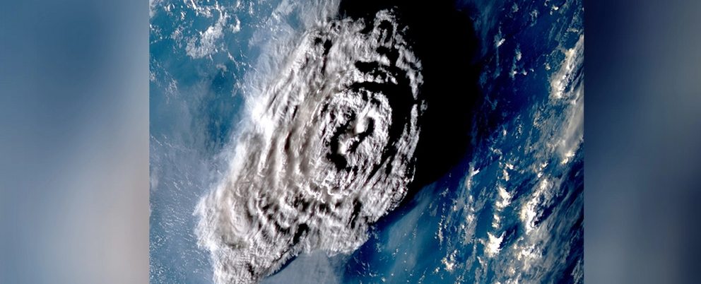
The Hunga-Tonga plume, imaged by the Japanese Meteorological Agency's Himawari-8 weather satellite.
A spectacular and explosive volcanic eruption in January 2022 produced the highest plume of steam and ash in recorded history.
The towering column that arose from Hunga Tonga-Hunga Ha'apai reached a tremendous altitude of 57 kilometers (35 miles) above sea level.
That height makes it the first-ever volcanic eruption seen to have punched completely through the stratosphere to breach the mesosphere.
"It's an extraordinary result as we have never seen a cloud of any type this tall before," says atmospheric scientist Simon Proud of Oxford University.
This maybe oughtn't to be a surprise: The eruption was one of the largest volcanic eruptions humanity has ever seen. But measuring the height of its plume with accuracy took some clever detective work.
The height of a volcanic plume is usually estimated based on the temperature profile measured by satellites taking infrared observations. Since thermal emission, or heat, produces infrared radiation, these satellites can detect volcanic plumes.
As plumes extend through the troposphere (that's the atmospheric layer closest to Earth, the one we live in), they lose heat, so the temperature of the top of the plume can be used to estimate height.
However, once the plume reaches the stratosphere, at an average altitude of around 12 kilometers, this strategy loses accuracy because the temperature profile of the plume changes again, this time becoming warmer. So, a team of researchers led by Proud took a different approach.
The researchers still relied on data from satellites, but the measurement was based on parallax. If you've ever closed one eye after another and watched objects close to you seem to shift from side to side compared to their background, you've seen parallax in action.
It's the difference between the apparent position of two objects seen along different lines of sight, and it's the basis of depth perception in binocular vision. Our brain processes the information from each eye and works out the distance to objects in view. We can use parallax to calculate all sorts of distances.
To obtain parallax measurements of the Hunga Tonga-Hunga Ha'apai eruption, the researchers used data from three geostationary weather satellites that observed the event from different positions in low-Earth orbit, taking images every 10 minutes.
From this, Proud and his team calculated that the plume reached a 57-kilometer altitude. Interestingly, this is very close to the 58-kilometer altitude NASA scientists calculated back in January using data from two geostationary satellites.
Previously, the highest volcanic plume on record was Mount Pinatubo in the Philippines; its 1991 eruption produced a plume that extended up to 40 kilometers in altitude.
The much greater height of the Hunga-Tonga plume, however, is a little baffling, given the Mount Pinatubo eruption was similar in strength: Both eruptions registered as a 6 on the volcanic explosivity index (VEI) scale.
There's an easy answer to this one, however. If the Hunga-Tonga plume had been measured using the Mount Pinatubo techniques, the maximum height would have been set at around 39 kilometers.
Even if Mount Pinatubo's plume reached higher than measured, though, we still don't know what the mechanisms are for reaching that altitude. So that could be a fun topic to explore.
We also don't know how a volcanic plume of that height would affect the mesosphere; since no other volcanic plume has been observed reaching that high, the effects have only been indirect.
A hazy substance was observed at the top of the Hunga-Tonga plume; what that is, and how long it will hang around up there, are unknown.
This means there's more work to be done to help us understand this fascinating and devastating event.
"We'd also like to apply this technique to other eruptions and develop a dataset of plume heights that can be used by volcanologists and atmospheric scientists to model the dispersion of volcanic ash in the atmosphere," says atmospheric physicist Andrew Prata of Oxford University.
"Further science questions that we would like to understand are: Why did the Tonga plume go so high? What will be the climate impacts of this eruption? And what exactly was the plume composed of?"
The research has been published in Science.