Canada opens world's longest hiking trail that stretches coast to coast
At 15,000 miles long, the 'Great Trail' took 25 years to complete.
The Great Trail — previously known as the Trans Canada Trail — is a bit of a misnomer. Given that the recently opened trail is the longest recreational one in the world at a staggering 14,864 miles, the project is great indeed, a monumental achievement. However, it isn’t a trail.
Similar to its daintier American cousin, the Maine-to-Florida spanning East Coast Greenway, the Great Trail isn’t a single trail but a collection of small, community-based trails, all maintained and operated by local jurisdictions, linked together to form a single network. It’s all a touch confusing but understandable why the Great Trail, composed of more than 400 individual trails snaking across all 10 provinces and three territories from St. John’s in the East to Victoria in the West with a huge looping detour north through the Yukon and Northwest Territories to the Arctic Ocean, would be billed as a single entity: “The Great Canadian Network of Interconnected Community Trails” just doesn’t have the same ring to it, now does it?
Naming aside, the Great Trail is a labor of love — “truly a gift from Canadians to Canadians” per the Montreal-based nonprofit organization that has overseen the complex, jigsaw puzzle-esque formation of the project since it first dreamt up in 1992. That said, the multi-modal (more on that in a bit) trail is largely the handiwork work of volunteers (it’s been dubbed the largest volunteer project in Canadian history) working within local conservation groups, provincial governments and municipalities. It would seem that everyone has pitched in a little bit over the last 25 years.
By land or by sea, the scenery is dramatic
While largely promoted as a super-linked-up cycling route, if you glance at a map of the Great Trail it becomes apparent that different modes of transportation are required — or encouraged — along different stretches. And indeed, individual sections of the trail are open to not just cyclists but hikers, horseback riders and cross-country skiers. Significant portions, such as the Lake Superior Water Trail and Mackenzie River Trail, are best — or can only be, rather — navigated by kayak or canoe. In fact, 26 percent of the Great Trail travels across water. And although motorized vehicles are verboten along the Great Trail, certain sections are also open to snowmobiles. (Hey, this is Canada, after all).
Whereas the East Coast Greenway tightly hugs the major cities and population centers of the Eastern Seaboard to offer an urban, commuter-friendly experience with sizable dashes of bucolic scenery thrown in for good measure, the landscapes found along Great Trail are decidedly more dramatic and diverse. After all, the Great Trail covers a hell of a lot more territory: mountains, lakes, plains, coastal islands, frozen tundra — seemingly every sort of terrain and topographical feature is represented.
This isn’t to say the Great Trail is a 100 percent backcountry wilderness affair.
In places, the linked trails are heavily urban — indeed, an estimated four out of five Canadians live within 30 minutes of a trail section. Moving across the country from its eastern terminus on the island of Newfoundland where it follows the T’Railway multi-use rail trail route, the Great Trail passes directly through several major Canadian cities: Halifax, Montreal, Ottawa, Toronto, Winnipeg and Edmonton. It’s here, in Alberta, that the trail(s) make a big split, dipping south toward Calgary and then across the Rocky Mountains clear across British Columbia to Vancouver Island or snaking northwards through Alberta and B.C. through the Yukon via Whitehorse and eventually winding upwards across the Northwest Territories to the Arctic Ocean.
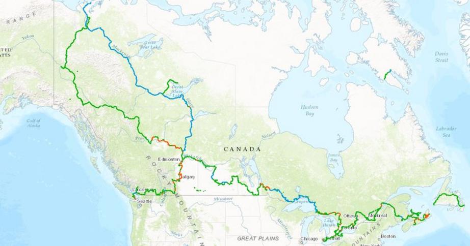
Oh, Canada! indeed: Green represents connected land trails, blue represents connected water trails and red indicates gaps that have since been connected. (Map: Great Trail)
Alternately, one paddle-centric subarctic branch of the trail, formed by the Althabasca River Trail, Slave River and Mackenzie River Trail, bypasses B.C. altogether, shooting upwards through Alberta and into the Northwest Territories where, near the town of Inuvik, it intersects with its western counterpart forming a giant loop. Unlike their decidedly less arduous urban and semi-rural counterparts to the southeast, the sections that comprise this leg of the Great Trail, such as the rough gravel road in the north Yukon otherwise known as the Dempster Highway, can be described as “remote, physically demanding” and offering “few available services.”
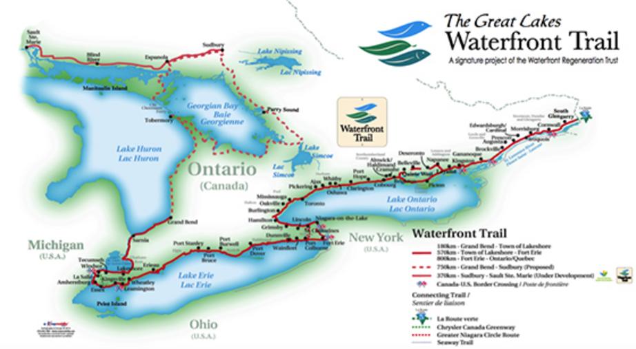
The Great Trail’s lengthiest section can be found in Ontario, where an assemblage of established trails zigzag around the Great Lakes.
Twenty-five years in the making, the Great Trail was a hugely ambitious project (not without a few detractors) that officially opened at the end of August 2017. So invest in a decent pair of hiking boots, renew your passport and start plotting …
For the rest of this article please go to source link below.
Video can be accessed at source link below.

