What is desertification, and where is it happening?
Regional climate, not proximity to deserts, determines a location’s risk.Desertification is a type of land degradation. It occurs when drylands become increasingly arid or desert-like. Desertification doesn’t necessarily mean that these water-scarce regions will transform into desert climates — only that their land’s natural productivity is lost and its surface and groundwater resources are diminished. (In order for a climatological desert to form, a location must evaporate all of the rain or snow it receives annually. Drylands evaporate no more than 65% of the precipitation they receive.) Of course, if desertification is severe and persistent, it can influence a region’s climate.
If desertification is addressed early enough and is slight, it can be reversed. But once lands are severely desertified, it is extremely difficult (and costly) to restore them.
Desertification is a significant global environmental issue, but it isn’t widely discussed. One possible reason why is because the word “desert” misrepresents the parts of the world and populations who are at risk. However, according to the Intergovernmental Panel on Climate Change (IPCC), drylands cover about 46% of the Earth’s land area, and as much as 40% of the United States. In theory, this means that roughly half of the world, and half of the nation, is susceptible not only to desertification, but to its negative impacts: infertile soil, loss of vegetation, loss of wildlife, and, in short, loss of biodiversity — the variation of life on Earth.
What Causes Desertification
Desertification is caused by natural events, such as droughts and wildfires, as well as by human activities, such as land mismanagement and global warming.
When trees and other flora are permanently cleared from forests and woodlands, an act known as deforestation, the stripped land can become much warmer and drier. This is because, without vegetation, evapotranspiration (a process that transports moisture into the air from plant leaves, and also cools the surrounding air) no longer occurs. Removing trees also removes roots, which help bind soil together; soil is therefore at greater risk of being washed or blown away by rains and winds.
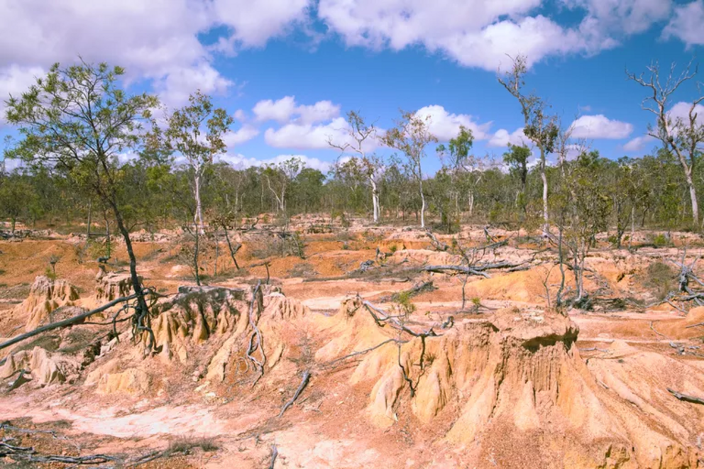
Soil Erosion
When soil erodes, or wears away, topsoil (the layer that lies closest to the surface and contains essential nutrients for crops) is carried away, leaving behind a highly infertile mix of dust and sand. Not only is sand less fertile, but due to its larger, coarser grains, it doesn't retain as much water as other soil types, and thus, increases moisture loss.
The conversion of forests and grasslands into farmland is one of the biggest sources of soil erosion. Globally, rates of soil degradation continue to be greater than those of soil formation.
Overgrazing can also lead to desertification. If animals continuously eat from the same patch of pastureland, the grasses and shrubs they consume aren't given enough time to continue growing. Because animals sometimes eat plants down to the roots and also feed on saplings and seeds, plants may stop growing altogether. This results in large, open areas where soil remains exposed to the elements and vulnerable to moisture loss and erosion.
Poor Farming Practices
Poor farming practices, such as over-cultivation (excessive farming on one piece of land) and monocropping (growing a single crop year-after-year on the same land) can damage soil health by not allowing sufficient time for soil nutrients to be replenished. Over-tilling (stirring soil too often or too deeply) can also degrade land by compacting soil and drying it out too fast.
One of the largest desertification events in U.S. history — the 1930s Dust Bowl — was triggered by such poor farming practices across the Great Plains region. (Conditions were also exacerbated by a series of droughts.)
Drought
Droughts, prolonged periods (months to years) of little rain or snow, can trigger desertification by creating water shortages and contributing to erosion. As plants die off due to lack of water, the soil is laid bare and is more easily eroded by wind. Once precipitation returns, the soil will also be more easily eroded by water.
Wildfires
Large wildland fires contribute to desertification by killing plantlife; by scorching soil, which decreases soil moisture and increases its vulnerability to erosion; and by allowing the invasion of non-native plants, which arises when burned landscapes are re-seeded. According to the U.S. Forest Service, invasive plants, which dramatically decrease biodiversity, are 10 times as abundant on burned landscapes than on unburned lands.
Climate Change
Earth’s global average air temperature has warmed about 2 degrees Fahrenheit since pre-industrial times. But land temperature, which warms more quickly than that over oceans or in the atmosphere, has actually warmed by 3 degrees Fahrenheit. This land warming contributes to desertification in several ways. For one, it causes heat stress in vegetation. Global warming also worsens extreme weather events like droughts and floods, that contribute to erosion. A warmer climate also speeds up the decomposition of organic matter in soils, leaving them not as nutrient-rich.
Where Is Desertification Taking Place?
Desertification hotspots include North Africa, Southeast Asia (including the Middle East, India, and China), Australia, and Latin America (the Central and South Americas, plus Mexico). Among these, Africa and Asia face the greatest threat, due to the fact that the majority of their lands are drylands. In fact, these two continents hold nearly 60% of the world's drylands, according to a report published in the journal Nature.
The western United States, especially the Southwest, is also highly vulnerable to desertification.
With 65% of its land considered dryland areas, it's no wonder that Africa is the continent most affected by desertification. According to the World Resources Institute, desertification in Africa is so extreme, the continent will be able to feed no more than one quarter of its inhabitants by the year 2025. The Sahel — the transitional zone between the arid Sahara desert to the north and the belt of Sudanian savannas to the south — is one of the continent's most degraded regions. Southern Africa is another. Both the Sahel and southern Africa are prone to severe drought conditions. Other drivers of desertification across the continent include climate change and subsistence farming.
Asia
Almost one quarter of India is undergoing desertification, largely due to water erosion from monsoons, loss of vegetation from urbanization and overgrazing, and wind erosion. Because agriculture is such a key contributor to India's gross domestic product (GDP), this loss of land productivity is costing the country as much as 2% of it's 2014-15 GDP.
Ninety percent of land in the Arabian Peninsula lies within arid, semi-arid, and dry sub-humid climates and is therefore at risk of desertification. The Peninsula's population growth (thanks to oil revenues, it has one of the highest annual population growth rates in the world) has hastened land degradation by increasing food and water demand in an already water-scarce region. Overgrazing by sheep and goats, and soil compaction by off-road vehicles (it makes water less able to filtrate through soil, and so, destroys vegetation cover) are also accelerating the desertification process in some of the most severely impacted Arab countries, including Israel, Jordan, Iraq, Kuwait, and Syria.
In China, desertification encompasses about 30% of the country's land area, according to the U.N.'s Food and Agriculture Organization. Desertification-induced economic losses there are estimated at $6.8 billion U.S. dollars per year. Northern China, especially regions near the Loess Plateau, is particularly vulnerable, and desertification there is largely driven by wind erosion and water erosion.
Australia
Australia's desertification is evident through the loss of its perennial grasses and shrubs. Drought and erosion are the main factors responsible for the expansion of its arid regions. Soil salinity — the accumulation of salts in soil, which increases soil toxicity and robs plants of water — is also a major form of land degradation in Western Australia.
Latin America
Across Latin America, the main causes of land degradation include deforestation, the excessive use of agrochemicals, and overgrazing. According to a study in the journal Biotropica, 80% of deforestation is occurring in just four countries: Brazil, Argentina, Paraguay, and Bolivia.
The Climate Change, Migration, and Security report estimates that desertification claims 400 square miles of Mexican farmland each year, and has led an estimated 80,000 farmers to become environmental migrants.
What Is the Global Impact of Desertification?
When desertification occurs, food insecurity and poverty levels rise as lands that once served as a source of food and farming jobs become infertile. The more desertification expands, the more people go hungry and the more livable habitats shrink, until eventually they must leave their homelands to find other places to make a living. In short, desertification deepens poverty, limits economic growth, and often results in cross-border migration. The United Nations (U.N.) estimates that by the year 2045, 135 million people (that’s the equivalent of one-third of the U.S. population) may be displaced by desertification.
Desertification is also taking a toll on human health by increasing the frequency and intensity of dust storms, particularly in Africa, the Middle East, and Central Asia. For example, in March 2021, an early-season dust storm — the largest to hit Beijing, China, in a decade — swept across northern China. Dust storms transport particulate matter and pollutants over great distances. When breathed in, these particles can trigger respiratory illness and even damage cardiovascular systems.
But desertification doesn’t just threaten humankind. A number of endangered animal and native plant species could become extinct as their habitats are lost due to degraded lands. For example, the Great Indian Bustard, an ostrich-like bird whose global population has dwindled to as few as 150 individuals, faces additional survival challenges as its dry grassland habitat declined by 31% between 2005 and 2015.
The degradation of grasslands is also linked to the endangerment of India’s Nilgiri tahr, which dropped to a population of 100 in 2007.
What’s more, about 70% of the Mongolian Steppe — one of the world’s largest remaining grassland ecosystems — is now considered degraded, largely as a result of overgrazing by livestock.
What Can We Do?
One of the key tools to limiting desertification is sustainable land management a — practice which largely prevents desertification from happening in the first place. By educating farmers, ranchers, land-use planners, and gardeners on balancing human needs with those of the land itself, land users can avoid overexploitation of land resources. In 2013, the U.S. Agricultural Research Service and the U.S. Agency for International Development launched the Land-Potential Knowledge System mobile app for this very purpose. The app, which is free and available for download anywhere in the world, helps individuals monitor soil and vegetation health by identifying soil types at their specific location, documenting rainfall, and tracking wildlife species that may live on their land. “Soil predictions” are also generated for users based on the data they enter into the app.
Other desertification solutions include rotational grazing of livestock, reforestation, and the planting of fast-growing trees to prevent shelter from the wind.
For example, the people of Africa are combating severe desertification by planting a nearly 5,000-mile-long wall of vegetation across Africa’s Sahel region. The so-called Great Green Wall initiative — a massive reforestation project meant to halt the advance of the Sahara Desert — has already created over 350,000 jobs and allowed over 220,000 residents to receive training on sustainable production of crops, livestock, and non-timber products. As of late 2020, nearly 20 million hectares of degraded land had been restored. The wall aims to restore 100 million hectares by the year 2030. Once completed, the Great Green Wall will not only be transformative to the lives of Africans, but a record-breaking accomplishment, too; according to the project’s website, it’ll be the largest living structure on the planet — roughly triple the size of the Great Barrier Reef.
According to the National Aeronautics Space Administration and an article published in the journal Nature Sustainability, solutions such as "greening" do work. Both say the world is a greener place than it was 20 years ago, largely due to China's and India's efforts to fight desertification by conserving and expanding forests.
Our global community can't hope to solve the problem of desertification if we don't fully realize its extent. For this reason, raising awareness of desertification is also necessary. A good place to start is by observing World Desertification and Drought Day alongside the U.N. every year on June 17.
For the rest of this article please go to source link below.