Maps tease apart complex relationship between agriculture and deforestation in DRC
New methods to differentiate tree cover loss due to agriculture from true deforestation have the potential to guide development efforts, bolster forest protections and inform land-use policy.
- A team from the University of Maryland’s GLAD laboratory has analyzed satellite images of the Democratic Republic of Congo to identify different elements of the “rural complex” — where many of the DRC’s subsistence farmers live.
- Their new maps and visualizations allow scientists and land-use planners to pinpoint areas where the cycle of shifting cultivation is contained, and where it is causing new deforestation.
- The team and many experts believe that enhanced understanding of the rural complex could help establish baselines that further inform multi-pronged approaches to forest conservation and development, such as REDD+.
When a farmer cuts down a tree in the Democratic Republic of Congo, there’s often a reason for it. She’s most likely clearing the land to plant crops — the rice and corn and cassava that will see her family through another year. And chances are good that it’s an area she, or her husband or father or mother, has cleared before. She’ll farm this plot for a few years, and then when the soil tires and the nutrients have been used up, she’ll move on to a new plot.
For all its bizarre and wondrous botanical diversity, the soil in the Congo Basin is pretty poor on the whole. So once the earth in a particular plot is spent, the farmer will leave it alone for a period of time, ranging from a few years up to about two decades in a place like the DRC. Then, she’ll move on to clear another patch of land, and the pattern repeats itself.
The problem for scientists looking at satellite images is that it’s difficult to figure out whether they’re seeing the clearing of land that’s been farmed for decades or centuries, or blasts of new deforestation in relatively untouched rainforest. Up until now, all of that tree cover loss has been lumped together for the most part, says geospatial scientist Giuseppe Molinario.
“It had always seemed to me like it was presented as a very clear-cut relationship,” Molinario said in an interview. “Slash-and-burn leads to deforestation.”
But scientists know that slash-and-burn farming — named for the axes and fire that farmers typically employ — doesn’t always have the same impact on the ecosystem as new incursions into untouched forest, at least not when this type of farming occurs within that contained area of land.
“You can say that there is a problem with deforestation, and there definitely is,” Molinario said. “But there are communities which aren’t problematic, and you have to point that out too.”
Without a rubric, a pixel of tree cover loss on a satellite photograph lights up in the same way, whether it’s a new pinprick in the sea of the world’s second-largest rainforest, or it’s an area that’s been cleared time after time. It’s also difficult to know what to do about instances of tree cover loss without more details.
In the past few years, Molinario and his colleagues at the Global Land Analysis and Discovery (GLAD) laboratory at the University of Maryland have been developing a new map starting from analyses of fragmentation patterns in DRC that allows them to differentiate types of tree cover loss within the mix of roads, villages, fields, fallows and forests that supports human life in the country. Within this mosaic, which scientists call the “rural complex,” Molinario’s team is trying to figure out which instances of expansion are leading to new deforestation.
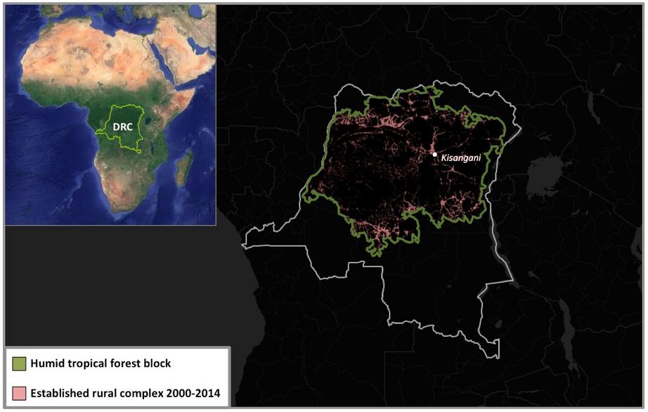
Image showing the area of interest for Molinario’s research, adapted from Molinario et al, 2017 (CC BY-SA 3.0). National boundaries and satellite imagery courtesy of Global Forest Watch and Google Earth.
It’s a tool that holds promise for conservationists, development agencies, and land-use planners because it can help highlight areas where halting expansion beyond the rural complex to save primary forest is a pressing concern.
“I just saw this disconnect and this gap in the way that people talk about deforestation and the Congo Basin and especially the DRC,” Molinario said, “because it was taken out of context.”
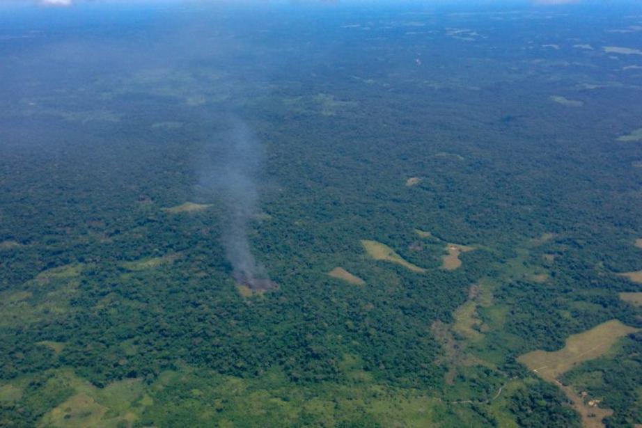
An aerial shot of farmers using fire to prepare a field for planting in DRC. Photo by John C. Cannon.
To gain a more nuanced understanding of what he and his colleagues were looking at, they picked 1,000 random points in the DRC’s rural complex. The scientists then zoomed in on high-resolution satellite images taken at those points and assigned one of 14 different classes of land use to the spot, ranging from a clearing to an active field, from secondary to primary forest. Next, they calculated the different proportions of each of those classes.
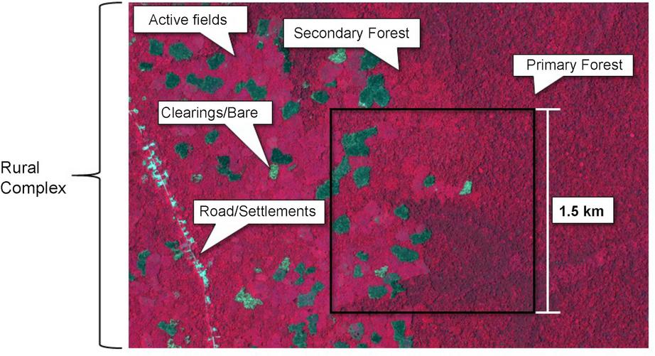
False color satellite image (Orbview 5) showing the different classes of land cover. Image from Molinario et al., 2017.
They found active fields cover about 10 percent of the rural complex, and 11 percent still supports primary forest. About one-quarter is covered with land left to lie fallow, and more than one-third is secondary forest. From their results, the team discovered that farmers are breaching the boundaries of the complex and spilling into primary forest at a rate of about 1 percent a year.
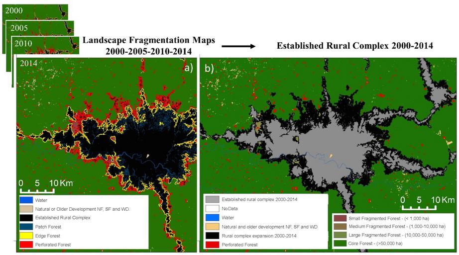
The researchers used landscape fragmentation maps from 2000-2014 (a) to develop maps of the rural complex baseline present in DRC in 2014. Image from Molinario et al., 2017.
How much of that is causing real problems for the environment? Tree cover loss leads to the substantial release of carbon, the destruction of habitat that’s vital to the plants and animals living in the forest, and the disruption of how water flows through the land. But the effects of new deforestation are much more pronounced than certain types of cyclical clearing for agriculture.
“It’s this weird kind of gray area in the dynamic of land-use change that can be quite sustainable, if it is within a certain constrained area and has nice long intervals,” said remote-sensing scientist Matthew Hansen. Hansen runs the GLAD laboratory, and his team’s data is the backbone of tools such as the forest monitoring platform Global Forest Watch.
When shifting cultivation isn’t contained and instead leads to what Hansen and Molinario call “perforations” in the forest cover, then you can get the suite of impacts that accompany deforestation.
And while these pressures aren’t only an issue for the DRC, such a large population that’s so dependent on subsistence agriculture sets the country apart.
“DRC is unique,” Hansen said. “DRC stands alone.”
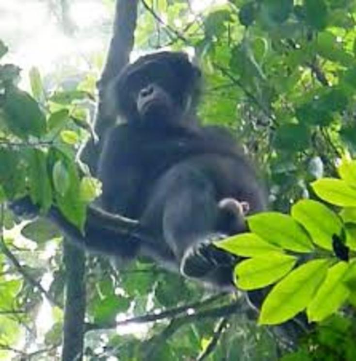
The bonobo is only found in the DRC, where deforestation has diminished its habitat. Photo by Martin Bendeler
Even in the country next door, the situation is dramatically different. In the Republic of Congo, a team from the World Resources Institute (WRI) leveraged the same methods that Molinario and his colleagues had developed in the DRC. Their aim was to bolster efforts in the Republic of Congo to reform how the country uses its land.
For one thing, a much smaller proportion of tree cover loss happens within this mosaic of cyclical agriculture. Only about one-third of the tree cover lost in the Republic of Congo happened in that context between 2000 and 2015. In the DRC, that figure was more than 60 percent.
“In the Republic of Congo, the shifting cultivation, this rural complex is way less developed,” said Thomas Maschler, a GIS and remote-sensing specialist at WRI.
Part of the reason is cultural, Maschler explained. Ethnic groups in the Republic of Congo have traditionally relied more on hunting and gathering than farming. Only about half of tree cover loss in the Republic of Congo stems from shifting cultivation. In the DRC, that figure is more than 92 percent.
The Republic of Congo also has more commercially valuable timber species, Maschler added, which has led to a more robust timber industry. Conversely, a moratorium on logging concessions in the DRC that’s held since 2004 and the cancellation of 120,000 square kilometers (46,332 square miles) of logging permits in 2009 has kept the proportion of the DRC that’s under shifting cultivation much higher.
The two countries do converge in the amount of expansion beyond the rural complex into forests. Between 2000 and 2015, the rural complex spilled into surrounding forest at a rate of about 1.6 percent per year in the Republic of Congo.
“This puts the loss we see in a little bit of perspective,” Maschler said. Right now at least, shifting cultivation leads to a relatively small amount of new deforestation. But can that trend hold?
“Due to the increase in population, the need for land automatically increases,” Maschler said.
The DRC is also unique in the way much of the tree cover loss and deforestation happens.
“In DRC, it’s just smallholders with axes,” Hansen said, “and they do something comparable to the other places that are using chainsaws and other machinery.”
The DRC ranks second in the world for the amount of forest cover it has, sitting between Brazil and Indonesia, where vastly different threats imperil their forests. In Brazil, massive soy plantations and cattle ranches are the dominant causes of deforestation, Hansen said. In Indonesia, with the third-most tropical forest cover, it’s oil palm.
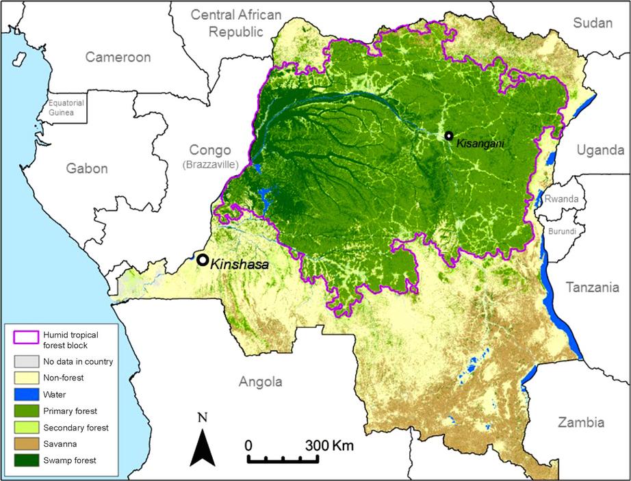
A map showing the rainforest cover in DRC. Image from Molinario et al., 2017.
By contrast, disruptions to the forest cover in the DRC show up in markedly different ways, Hansen said.
“Change is more and more dispersed throughout the forest,” he said, “unlike … a front of deforestation you might see in in Brazil.”
That dispersion could mean that while total area of forest remains high, “perforations” of standing forest can still be destructive to habitat. A 2017 study in the journal Nature found that the first intrusions into the forest create pulses of biodiversity loss.
Then, once established, Maschler said, “These little clearings … grow slowly over time.” Scientists describe this type of deforestation as “contagious” for its propensity to spread.
But what drives farmers into the forest, when it seems easier to stay close to established roads and settlements?
One concern is the exhaustion of the land. As soils grow increasingly depleted, and the DRC’s population continues to rise — from more than 83 million now to perhaps 200 million by 2050 — it can drive farmers to expand beyond their traditional plots.
At that point, Hansen said, “You’re always colonizing new frontier forest, or you start shortening the fallows and really start degrading the environment.”
Deplete the nutrients enough, and you get what Hansen calls “derived savannas” that can’t recover from the pressure that comes with intensive farming. “The forests won’t come back under certain conditions,” he said.
In addition to a growing population that’s hungry for more farmland, the DRC is beset with an unmatched level of violence and disorder. Indeed, in the 2015 study that Molinario led, the researchers found the provinces of North Kivu and South Kivu had some of the highest rates of expansion into surrounding forest and subsequent forest loss between 2000 and 2010.
The authors chalk this up to a big increase in the population following the Rwandan genocide in 1994 and little to no support for increasing food production on land that was already under cultivation. This trend also shows few signs of abating. The crisis news service IRIN reported that in 2016, 1.7 million people — nearly double the number in 2015 — fled from their farms and villages in the DRC because of unrest. The Global Forest Watch team also highlighted about 5 square kilometers (1.9 square miles) of new deforestation in the last few months of 2017 as a result of rebel activity near the town of Beni in North Kivu province.
In fact, the dearth of adequate infrastructure in the DRC to address these issues is a problem for the country in general, experts say.
“I think one of the big issues of DRC — why DRC is a problem — is because it is the most populated country [in] Central Africa and with very high demographic growth,” said Alain Karsenty, an environmental economist at the French Agricultural Research Centre for International Development (CIRAD) in Montpellier, France. “And you have no government.”
Projects such as the Central African Forest Initiative, or CAFI, are working to fill that gap.
Ian Gray, a sociologist at the University of California, Los Angeles, spent several months in the DRC in 2011, working both inside the Ministry of the Environment in the capital, Kinshasa, as well as time in the field in the province of Equateur. He was looking at the marketization of carbon and efforts to couple it with development goals.
The broader strategy behind the CAFI effort has been to use the carbon banked in the forests of developing countries in the Congo Basin, like the DRC, as a reason to protect them. In exchange for safeguarding these forests and the carbon stocks contained within, the DRC gets funding from richer countries to plow into development.
“In some ways, it’s like a theater of the absurd,” Gray said. “You’re instituting this unbelievably sophisticated system of tracking each ton of carbon in the country’s forest reserves and doing it in a setting where there just are not the means to make it happen.”
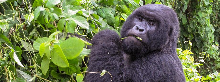
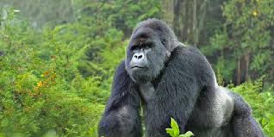
A mountain gorilla in DRC. Poaching and habitat loss remain threats to this critically endangered species. Photo by John C. Cannon.
The scheme has been codified by the UN as the REDD+ program, which aims to reduce deforestation-caused carbon emissions through conservation, sustainable management of forests and enhancement of forest carbon stocks. In 2015, the approach got a big boost from its inclusion in the Paris climate accords.
The approach has attracted its share of skeptics. But at the same time, Gray said it just might provide the underpinnings of an effective land-use policy.
“I think REDD+ is bringing in resources that are starting to build some of that institutional framework,” Gray said.
And that just might be a spot where the maps that Molinario and his colleagues have developed could help inform decision makers. Indeed, the team’s maps can provide a baseline showing where farming and deforestation are taking place to inform strategies such as REDD+. Molinario’s maps “illustrate and allow us to compare how shifting cultivation affects forests in DRC across landscapes,” according to the GLAD website.
Economist Amy Ickowitz of the Center for International Forestry Research (CIFOR), who was the lead author of a 2015 paper on deforestation and agriculture in DRC, praised the team’s work for helping “fight again the simplistic narrative that [shifting cultivation] results in deforestation.”
“They are good at showing the complexity of the existing relationships between [shifting cultivation] and forest impacts,” Ickowitz said of their 2015 study.
These relationships include descriptions of the interplay between agriculture and deforestation in areas connected by roads, for example, or in places where shifting cultivation seems to be occurring while leaving the surrounding forest undisturbed, such as in northeastern DRC.
These details provide “a great start when looking at land use planning priorities for governments,” Ickowitz said.
Still, nearly everyone acknowledges that there’s no simple way to address these problems.
“I believe that if intensification could be practiced in a way that is sustainable and improves livelihoods and food security and nutrition, then who could argue against it?” Ickowitz said. “In reality though, it is often difficult to find such win-win-wins.”
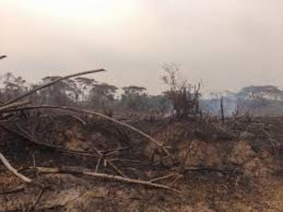
A farm smolders before planting.
For full references please use source link below.