Evidence grows that Hawaii’s volcanic eruption may have been caused by Puna Geothermal Venture
In my May 15 article, I described how the creation of a massive tsunami through a collapse of the Hilina slump was the secret purpose behind the creation of the Puna Geothermal Venture, whose owners are linked to the Rothschild family. I wish to state for the record that I don’t believe the plan will succeed, and that the hoped-for megatsunami that would cripple the United States economically and militarily for decades to come will not occur. However, it is vitally important to expose this plan was and who is behind it. Michael Salla
The surge in volcanic activity in the lower Puna region of the Big Island of Hawaii is concentrated in the area surrounding the Puna Geothermal Venture. Scientific data clearly links the unacknowledged fracking activity at the Puna Geothermal Venture as a factor in what is occurring with lava flows and earthquakes.
More scientific data shows how the fracking may have been deliberately designed to create a geological process by which lava would drain from Kilauea’s summit into the East Rift Zone so as to create large new vents that would destabilize the geology, and possibly trigger a major collapse in the Hilina Fault System.
A video prepared by Pacific Tsunamic Warning Center clearly shows that the epicenter of earthquake activity centered in the lower Puna region is adjacent to the Puna Geothermal Venture.
The following map from the video depicts all the earthquakes and the eruption site for the recent lava outbreak from 30 April to 6 May. The eruption occurs mainly in Leilani Estates, which is right next to the Puna Geothermal Venture. [See the map photo by clicking on "Read more here” at the end of this posting]
The following map by the US Geological Service shows where the Puna Geothermal Venture (marked PGV) is in relation to the current volcanic eruption.
Here’s a photo showing the lava outbreak and its very close proximity to the Puna Geothermal Venture (circled in red) on May 22. Since then, it has begun flowing onto the property, but still not reached any of the wells. [S[See the map photo by clicking on "Read more here” at the end of this posting]p>
The scientific data clearly shows how the Puna Geothermal Venture (PGV) is at the epicenter of the volcanic eruption. Is this merely chance or by design?
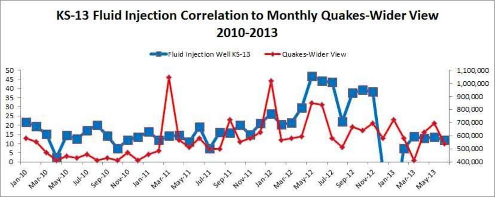
In my previous article and video published on May 15, I wrote about how the fracking activity at PGV has been scientifically linked to earthquakes. The following diagram was included which clearly showed the strong correlation:

Source of earthquake data: Advanced National Siesmic System – ANSS, Source of Injection Data is the EPA
Since the publication of my article, there have been other articles linking the fracking at PGV with earthquakes, and also raising the question of whether the fracking caused the volcanic eruption. The most prominent one has come from Jon Rappoport, who wrote a May 22 article on his blogsite titled: “Did fracking cause the Hawaii volcano eruption?”
In my May 15 article and video, I mentioned the Hilina Slump and how it may have been related to the fracking occurring at PGV. This has led to much criticism in the video’s comments section, but the scientific facts do show that earthquake activity is related to movements in the Hilina Fault System. Here’s a map showing the Hilina Fault System in relation to the East Rift Zone. [See[See article photos by clicking on "Read more here” at the end of this posting]
The following map produced by the Hawaii Volcano Observatory shows how the recent earthquake activity led to the Hilina Slump slipping towards the Pacific Ocean Observatory by about two meters, which is massive in geological terms. [See a[See article photos by clicking on "Read more here” at the end of this posting]div id="attachment_10193" class="wp-caption aligncenter">
Here’s how an article produced by the Berkeley Seismology Lab explained the above photo:
While the earthquakes under the summit and under the eruption center at the eastern end of the rift zone are generated by the movement of magma, the big event and its aftershocks under the pali have a different origin. This becomes obvious in Figure 2 [reprodu[reproduced above]ws how the permanent GPS stations installed and operated by the Hawaii Volcano Observatory moved in response to the 6.9 quake. The red arrows indicate the direction of horizontal motion and all of them point to the southeast. The length of each arrow represents the extent of the motion with the longest ones having moved by more than 2 feet. This shows that the flank of the cliff on the southern coast of Hawaii has moved further towards the ocean.
What the article didn’t mention was that the 6.9 quake on May 4 was triggered by the massive outflow of lava from Kilauea Summit, Halemaʻumaʻu crater, into the East Rift Zone. Basically, the volcanic eruption in the Lower Puna region (where the Puna Geothermal Venture is located) is being fueled by fresh lava from the summit of Kileaua, which is being drained towards it.
While it began slowly as old lava oozed out of the new volcanic fissures in Leilani Estates, the recent upsurge is a result of fresh new lava arriving from the Kilauea Summit. The Honolulu Advertiser explained the process:
The first weeks of the eruption saw pasty, crumbly, slower-moving aa lava oozing slowly through the fissures. But that changed Friday afternoon, scientists said, when preliminary results from a testing sample showed a different composite of lava, the smoother pahoehoe variety that is generally fresher, hotter and faster.
[Read more here]v class="uk-text-center uk-margin-large-bottom">
Originally entitled: “Evidence Grows that Hawaii Volcanic Eruption Caused by Puna Geothermal Venture”
Video can be accessed at source link below.

