LiDAR technology helps archaeologists find two lost ancient Maya cities in Mexico
In addition, researchers have reported discovereding "monumental structures" as well as pyramids.
Technology is helping archeologists make new discoveries that would otherwise have been nearly impossible. The more experts embrace technology, the easier it becomes to look for ancient cities that have been retaken by nature, after having been created thousands of years ago.
LiDAR technology has proven to be a fascinating archeological tool, and evidence of that is the discovery of entire cities that have remained hidden from sight.
LiDAR–which stands for Light Detection and Ranging, has been embraced by archaeologists due to its incredible ability to examine the surface of the planet. LiDAR is a remote sensing method that makes use of light in the form of a pulsed laser to measure ranges.
Back in March, archaeologists reported having revealed the existence of a massive ancient 100-kilometer stone road constructed by the ancient Maya. The road system has a total volume to fill approximately 2,900 Olympic pools.
LiDAR is an incredible archeological tool and evidence of that is this discovery, made in June 2020, when archaeologists discovered an entire lost city without making a single excavation.
Archaeological discoveries that were made with the aid of LiDAR are well attested to this date.
Now, it has been reported by Mexico’s National Institute of Anthropology and History (INAH) that archeologists have found the remnants of two lost Maya cities–and a plethora of ancient monuments–thanks to a combination of LiDAR scans and archaeological fieldwork.
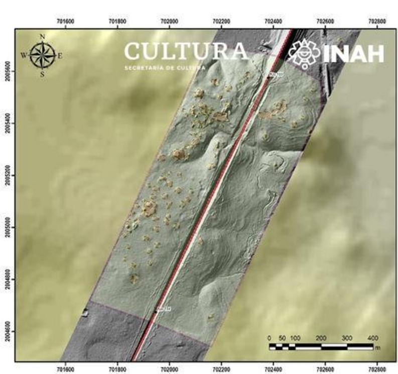
According to reports, the two cities were discovered in the state of Campeche. LiDAR helped experts identify “monumental” buildings in both cities that are comparable in size and complexity to the pyramids of Tikal.
The ancient city of Tikal was one of the most prominent and important cities of the great Maya Empire.

An image showing one of the sections where experts identified monumental ancient Maya structures. Image Credit: INAH.
The discovery of the new cities was made as a result of the Proyecto Tren Maya (PTM), a project that aims to better understand the history of the Maya civilization by surveying points of interest across various states.
The new archeological project saw experts survey a corridor of interest that extends over several hundred kilometers. As reported by INAH, the points of interest are divided into two groups; sections 1 and 2.
Experts have identified archaeologically important sites, among which important structures of different dimensions and characteristics predominate in both sections.
In Section 1, which runs from Palenque to Escárcega and covers over 230 kilometers, researchers spotted 553 archaeological monuments, some of which correspond to the location of archaeological sites previously registered by INAH, and others have been documented for the first time.
Due to the density of these assemblages and their relationship with the project layout, critical areas were defined where specific measures will have to be established to avoid their possible impact on the construction process of the work.
In section 1 archaeologists discovered a plethora of monuments which correspond to pre-Hispanic monumental buildings, surrounded by housing units.
Pyramidal bases, squares or quadrangles, and terraces are observed in LiDAR surveys of the area, highlighting a large structure on which several mounds stand.
Some of the registered buildings were partially affected during the construction of the old railway line.
Section 2 is made out of dozens of archeological elements with both monumental and residential characteristics, but experts say that further archeological fieldwork is needed in order to understand the impact of the site.
As revealed by INAH, knowledge of both sites is limited mostly because the PTM is still in the surface prospecting stage, which means that no excavations have yet been made that could reveal elements about the chronology or architectural characteristics.
In this phase of the project, the priority has been the documentation of the elements that were marked as being potentially archaeological in nature based on LiDAR images.
Although still in the early stages, the project led by INAH has made incredible discoveries.
It is worth mentioning that Section 2, which runs from Escárcega to Calkiní with a length of 234.94 kilometers, has revealed as many as 1,634 archaeological monuments of different characteristics, including various ancient structures whose exact purposes are yet to be identified, as per a report by INAH.
The project aims to survey sites in the states of Chiapas, Tabasco, Campeche, Yucatan and Quintana Roo.
A statement by the INAH has revealed that specialized work groups have been formed that carry out field trips in each section of the PTM in order to verify and document the discoveries.
The information generated and processed to date has made it possible to monitor and record, in real time, the exact location and characteristics of the archaeological remains, el Universal revealed.

